
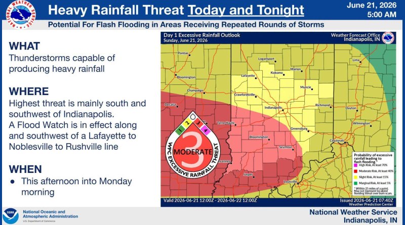
Emergency officials warn of heavy rain, flooding, storm dangers today
From Bartholomew County Emergency Management Department:
Bartholomew County is included in the potential for severe weather from this afternoon through Monday morning and remains under a Flood Watch from 2PM today through 8AM Monday.
Severe Weather Potential (Today – Monday)
Bartholomew County has been upgraded to a Slight Risk (2/5) for severe weather and a Moderate Risk (3/4) for excessive rainfall and flash flooding for today into Monday.
Multiple rounds of thunderstorms are expected from this afternoon into early Monday morning.
Severe storms are possible this afternoon and tonight, mainly in the 3 PM to 1 AM time frame.
Damaging winds and isolated tornadoes are the primary severe threats.
Heavy rain and flooding are also possible. 1 to 3 inches of rain are expected this afternoon into early Monday morning, with locally higher amounts possible. This could lead to flash flooding.
Hazards:
- Damaging Winds – 60-70 MPH possible
- Isolated Tornadoes – a strong tornado is possible
- Large Hail – 1” diameter
- Heavy Rainfall
- Flash Flooding
Expected Timing:
- 3PM to 1AM
Preparedness Actions:
- Stay weather aware and monitor forecasts closely
- Have multiple ways to receive warnings, especially during the evening and overnight hours (NOAA Weather Radio, Wireless Emergency Alerts, weather apps)
- Do not drive through flooded roadways — Turn Around, Don’t Drown
- Secure loose outdoor objects ahead of strong winds
- Know where you will take shelter if a warning is issued
- Charge cell phones and electronic devices in the event of power outages
From the National Weather Service:
FLOOD WATCH REMAINS IN EFFECT FROM 2 PM EDT THIS AFTERNOON
THROUGH MONDAY MORNING…
* WHAT…Flooding caused by excessive rainfall continues to be
possible.
* WHERE…Portions of central, south central, southeast, southwest,
and west central Indiana, including the following counties, in
central Indiana, Bartholomew, Boone, Clinton, Decatur, Hamilton,
Hancock, Hendricks, Johnson, Marion, Morgan, Rush and Shelby. In
south central Indiana, Brown, Jackson, Lawrence and Monroe. In
southeast Indiana, Jennings. In southwest Indiana, Daviess,
Greene, Knox, Martin and Sullivan. In west central Indiana, Clay,
Fountain, Montgomery, Owen, Parke, Putnam, Tippecanoe, Vermillion,
Vigo and Warren.
* WHEN…From 2 PM EDT this afternoon through Monday morning.
* IMPACTS…Excessive runoff may result in flooding of rivers,
creeks, streams, and other low-lying and flood-prone locations.
* ADDITIONAL DETAILS…
– Rainfall of 1 to 3 inches are expected with locally higher
amounts possible.
– http://www.weather.gov/safety/flood
PRECAUTIONARY/PREPAREDNESS ACTIONS…
You should monitor later forecasts and be alert for possible Flood
Warnings. Those living in areas prone to flooding should be prepared
to take action should flooding develop.
